Sorry, you need to enable JavaScript to visit this website.
Skip to main content
Banner Image

News

AAAS S&T Fellowship

AAAS Science & Technology Policy Fellowships (STPF) application deadline is on November 1.

Weather Service Snow Map

Late snow was reported in 11 states in the US Midwest, where places such as northern Minnesota, received 10.9 inches of snowfall, setting multiple records for May as reported by the Washington Post.

The U.S. Upper Midwest and Plain States received widespread thundersnow, winds gusts close to 70 mph and over 2 feet of snow in spots, and led to hundreds of canceled flights at Denver International Airport, and hundreds of schools canceled classes in Minnesota, Nebraska and South Dakota as reported by CBS.

US Highway 281 Bridge in Northern Nebraska

Nebraska experienced historic flooding and extreme weather conditions following days of snow and rain that swept through the West and Midwest in early March 2019. According to the NBC News, March 16, 2019,  thousands of people in eastern Nebraska and some parts in western Iowa were urged to evacuate as a massive late-winter storm pushed streams and rivers out of their banks throughout the Midwest.

MODIS natural-color images of the Sierra Nevada on February 11, 2019

Back-to-back storms in February caused by atmospheric rivers dropped more than eleven feet (3 meters) in places such as California's Sierra Nevada. As on 12 February, 2019, Mammoth Mountain had received enough to make it the snowiest ski resort in the United States. See other news

A powerful polar vortex was expected to bring some of the coldest weather to the US Midwest in a generation with some parts of the region being predicted colder than the Arctic Circle according to several news media stories such CBS News and New York Times

Silver Spring, Maryland, January 13, 2019

Depending on the location, total snowfall in areas from Washington D.C. south into Virginia saw higher amounts, up to a foot of snow, while the immediate D.C. metro area saw anywhere from 6 to 10 inches. According to the Washington Post, the storm snowfall total at Reagan National Airport was 5.4 inches, making this the snowiest storm since the January 2016 blizzard (17.8 inches) in Washington DC. 

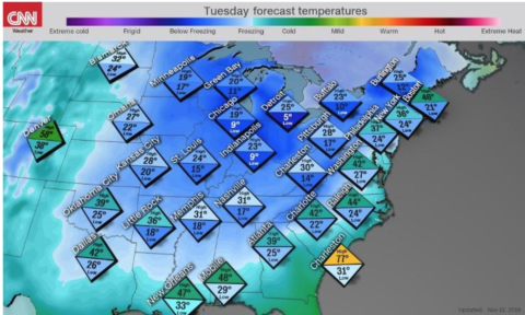
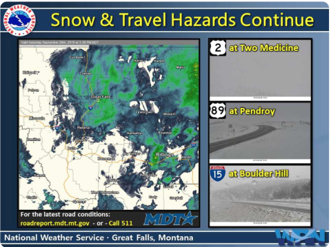
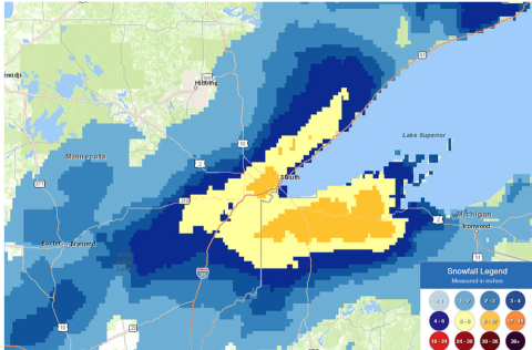
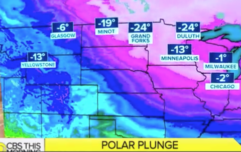
A record breaking winter storm caused chaos on a busy Thanksgiving holiday weekend, which brought more high winds, snow and rain as it pushed from the Midwest towards the Great Lakes and into the northeast US.  News media such as CNN reported that up to 60 inches of snow fell in Colorado and Wyoming, through the Midwest, including Iowa, which got up to 17 inches. The storm impacted the Chicago area, with more than 7 inches of snow, making it the strongest November storm since 1975 and the fifth-largest on record for the month.

A pre-winter storm from western North Carolina to Maine brought freezing weather in mid-November 2018 and allowed snow to fall as far down as the deep south, hitting Arkansas, Mississippi and Louisiana.  As reported by the New York Times, the New York region was nearly paralyzed by 6 inches of snow, while the Washington DC area received anywhere from an inch to four-plus inches of snow and sleet according to the

Some areas of the western U.S. and Canada will likely experience flooding caused by rain falling on snowpack and could more than double by the end of this century due to climate change. This is according to a new research conducted by the University of Colorado Boulder and the National Center for Atmospheric Research (NCAR) and published in the journal Nature Climate Change.

After five years of operation, the Airborne Snow Observatory team at NASA JPL led by Dr. Thomas Painter has been conducting snow surveys every winter to help calculate the “snow-water equivalent,” or the total volume of water stored in the Sierra snowpack and hence, provide an estimate of how much water will run off the mountain in the spring. Click on the "MIT Technology Review" link below for details.

A cold wave over the U.S. in early 2018 and four nor’easters contributed to widespread snow accumulation across the entire country, where places such as Mount Baker in Washington received heavy snow of about 850 inches (more than 70 feet) and Northern suburbs of Atlanta had about 10 inches -- an inch or so more than Washington, D.C., as reported in The Washington Post. 

A second nor'easter winter storm to hit the U.S. Northeast in less than a week dumped more than a foot of snow in some regions on March 7, which was captured by the GOES-16 satellite (see below Space News), leaving hundreds of thousands of homes in the Northeast without electricity as widely reported by the media.  

A new study published in the Proceedings of the National Academy of Sciences of the United States of America (PNAS) has demonstrated the feasibility of seasonal snowpack predictions and quantified the limits of predictive skill 8 months in advance using observations, climate indices, and a suite of global climate models.

Following a rare snowy morning in Atlanta,Georgia, resulting in mass school cancellations and traffic gridlocks throughout the region, Dr. Marshall Shepherd, Chair, Earth Science Advisory Committee, shared some useful insights on snow in Forbes, an American business magazine. See below: