

Despite snow’s unique importance to the global Earth system, no single satellite-borne sensor has been demonstrated to accurately measure all of the planet’s snow water equivalent. Seasonal snow cover is the largest single component of the cryosphere in areal extent, covering an average of 46 million km2 of Earth's surface (31% of land area) each year, and is thus an important expression of and forcing of the Earth’s climate. In recent years, Northern Hemisphere snow cover has been declining at a rate greater than Arctic sea ice. More than one-sixth of the world’s population (~1.2 billion people) relies on seasonal snowpack and glaciers for their water supply. Snowmelt-generated water supply is likely to decrease this century. Snow is also a critical component of Earth’s cold regions ecosystems where wildlife, vegetation and snow have strongly interconnected fates.
(Vuyovich et al., 2024 - Chapman Conference poster)
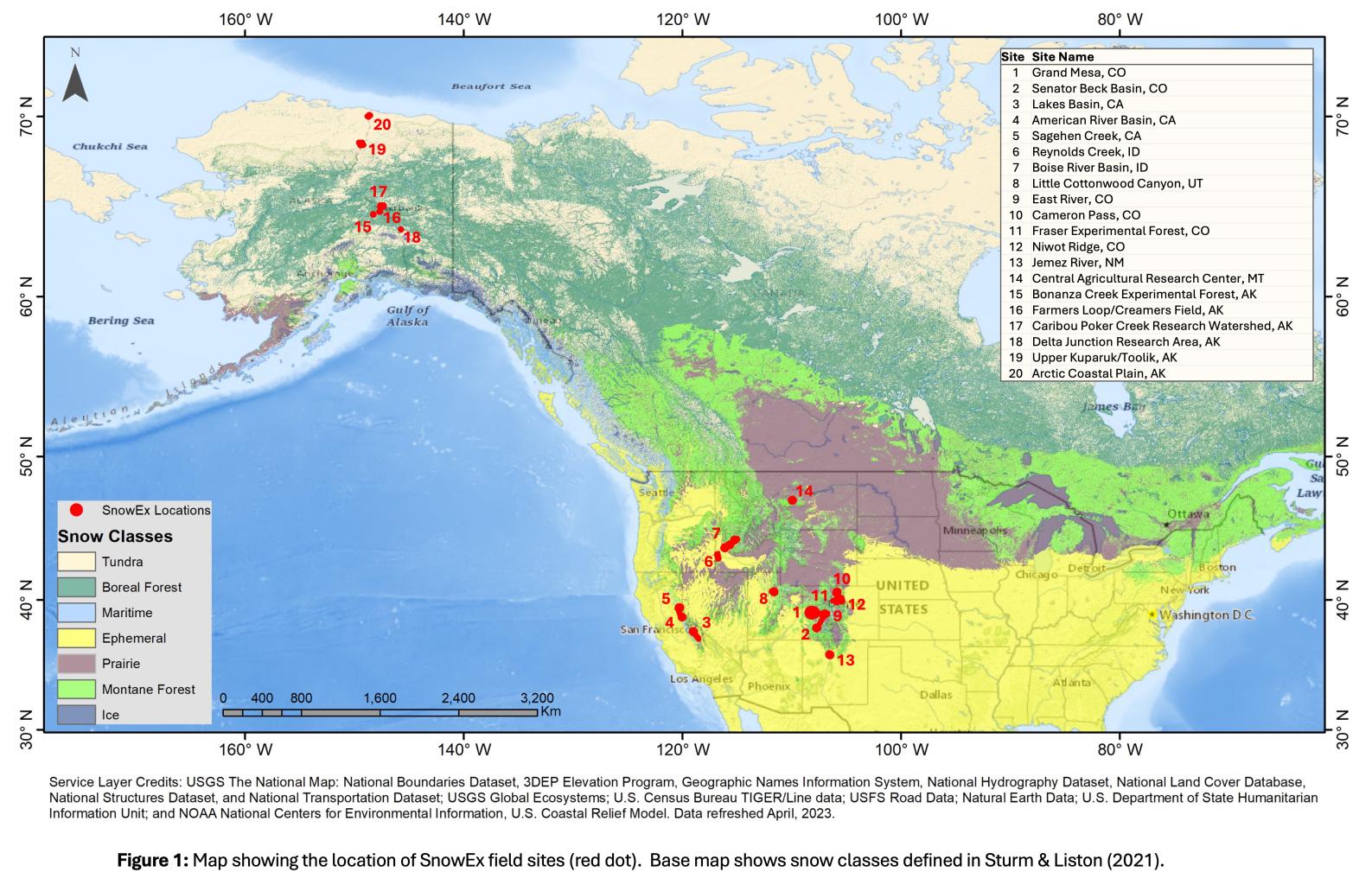
SnowEx - what is it?
SnowEx is a multi-year field experiment, which includes extensive surface-based observations to evaluate how to best combine different remote sensing technologies to accurately observe snow throughout the season in various landscapes. By dividing the world’s snow covers into different types, we can match the appropriate tools to each snow type and confounding factor. The various snow classes take into account the wind, precipitation, and temperature regimes these snow covers evolve within, and that depth, density, number of layers, grain characteristics, metamorphic trajectories and melt sequences differ across these various types of snow. Each snow type contributes in an important way to the hydrology and climatology of the Earth.
We identify seven gaps that represent breaks in the continuity of our knowledge of seasonal terrestrial SWE remote sensing techniques that have great relevance for advancing global snow science and, if addressed, could ultimately lead to a spaceborne snow mission concept. In addition, techniques found to improve seasonal terrestrial snow estimation have the potential to advance estimation of snow on sea ice, and perennial snow on glaciers and ice sheets. These gaps, that could be filled with a focused airborne and field campaign, are:
1. Forest snow
2. Mountain snow
3. Tundra snow
4. Prairie snow
5. Maritime snow
6. Snow surface energetics
7. Wet snow
Forest Snow: An estimated area of four million km2 of forest in the mid-latitudes and 11 million km2 of boreal forest (i.e. higher latitudes) is impacted by seasonal snow, which plays a crucial role in global biogeochemical and ecological cycles. Our ability to measure snow in forests has been limited because existing remote sensing technologies cannot fully see snow through tree canopies and masking effects of tall vegetation makes it difficult to quantify the albedo and surface temperatures. Newer sensing techniques have unquantified accuracy under forest conditions.
Mountain Snow: Mountain snow acts as a natural reservoir where water during the cold season is retained and later released as snowmelt. Mountainous areas provide disproportionately more streamflow than corresponding lowland areas downstream [Viviroli et al., 2007], and in many mountain ranges globally the majority of precipitation falls as snow. The primary challenges of measuring snow in mountains include deep snow, high spatial variability, and topographic shading. Physical processes that govern snowpack mass and energy balance in mountains can vary over multiple length scales, depending on gradients in elevation, slope, and aspect. In that sense, mountains may be considered a special subset of topographic complexity.
Tundra Snow: Tundra is the most representative biome of arctic land regions underlain by permafrost, covering ~8 million square km (~5.4% of the land surface of the earth vs. 7% for boreal forest). Warming promotes thawing of permafrost which affects the hydrology of the arctic through a deeper active layer (the upper portion of the tundra and permafrost which thaws during the summer), increased soil moisture storage, warmer soil temperatures, increased evaporation, and release of long-sequestered carbon. Tundra snow also affects iconic wildlife such as caribou and Dall sheep who depend on adequate winter forageable area and shallow snow for migration. The snow measurement challenge in tundra areas is tied to the relatively thin snowpack (<1m depth, and 0.35m is typical), huge metamorphic changes inside the pack over the winter (due to thermal gradients >100K/m) cause large contrasts in snow microstructure, and a rapid melt (e.g, 1 week).
Prairie Snow: Prairie and tundra cover over 16 million square kilometers, or about 10 percent of the land surface area of the planet. Prairie snowpack is generally shallow, and microwave observations have shown promise. However the subsurface characteristics (e.g. soil moisture, vegetation) can significantly impact the signal. As this snow climate is generally mid-latitude, lower elevation, and generally warmer, wet snow is also an issue, especially in fall and spring.
Maritime Snow: Maritime snow covers over 3.6 million square kilometers, and provides a significant source of water to coastline areas. Snow in these regions is generally deep, and often wet due to rain-on-snow and warmer convective events. Remote sensing techniques are also affected by vegetation and the common occurrence of cloud cover in these areas. In part due to the challenge of wet snow and maturity of techniques, maritime snow has received less attention during previous snow remote sensing efforts.
Snow Surface Energetics: Understanding changes in SWE over short (hourly-seasonal) and long (annual-decadal) time scales requires accurate assessment of the snowmelt energy balance. Remote sensing can provide insights into the thermal state (via snow surface temperature from IR sensing) and melt state (via albedo from spectral imaging spectrometry) of snowpack. In some regions (e.g., very cold snow zones), it is possible that climate warming may be manifested in changes in the snow surface energetics years or decades before changes can be detected in the form of declining SWE. The snow surface temperature and albedo are physically linked, as temperature is one factor controlling snow grain growth, and reduced albedo increases snow temperature (or can cause snowmelt once at the melting point).
Reductions to land surface albedo - due to loss of seasonal snow and/or decay of snow albedo - has important consequences to global climate through albedo feedback. Air temperature projections using the current global circulation models are challenging especially in forested and mountainous regions due to large uncertainties associated with snow albedo feedback. There is a pressing need to obtain high quality observations of snow surface albedo in these regions, but landscape heterogeneity complicates our efforts. There are also challenges associated with representativeness of either ground-based, airborne or satellite albedo measurements (Román et al., 2009; 2011; Wang et al., 2014), with the angular dependence of both sun and sensor further challenging accurate retrievals.
Wet Snow: The spring snowmelt period is a critical time for monitoring snow for both water resources and flood forecasting. An accurate estimate of the snowmelt magnitude and the timing of melt runoff is important for water management, however many remote sensing techniques cannot “see” through wet snow. Furthermore, altimetry and differencing methods require an estimate of snow density to convert depth to SWE often obtained from models, however the spring melt period is also when most model uncertainty is high (Essery et al. 2013).
These measurement challenges are further exacerbated in maritime snow and snow in transitional zones which can experience wet snow throughout the winter season due to rain on snow or melt events.