Sorry, you need to enable JavaScript to visit this website.
Skip to main content
Banner Image

Instruments

The airborne SWE Synthetic Aperture Radar and Radiometer (SWESARR) instrument was developed at NASA Goddard Space Flight Center. SWESARR has three active (including a dual Ku band) and three passive bands. Radar data is collected in dual polarization (VV, VH) while the radiometer makes single polarization (H) observations. The combination of all these microwave measurements will provide an important data set to develop and to enhance SWE retrieval algorithms.

Operation IceBridge utilizes the Center for Remote Sensing of Ice Sheets (CReSIS). This instrument measures the thickness of snow on top of sea ice and annual accumulation layers of firn over land ice, which allows researchers to make more accurate sea ice thickness measurements. The instrument is an FMCW radar which sweeps over a bandwidth of 2-18 GHz allowing a range resolution of better than 1 cm in snow.

CoSSIR is an airborne imaging radiometer with 12 channels from 183 GHz to 874 GHz that has flown in NASA’s ER-2 and WB-57 aircraft. The frequency set is optimal for sensing ice clouds and falling snow, and the sensor is capable of conical and cross-track scan modes.

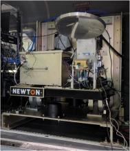
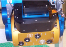
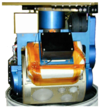
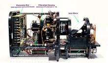
CoSMIR is nine channel total power radiometer, spanning 50 GHz to 183 GHz, originally designed for calibration and validation of the Special Sensor Microwave Imager/Sounder. Since its construction, it has been modified to conform to the GPM Microwave Imager (GMI) high frequency channels. CoSMIR has flown on NASA’s ER-2 and DC-8 aircraft. The two-axis gimbaled scan mechanism allows for a variety of scan strategies, including conical and across-track scans.

HIWRAP is a solid state dual-band (Ku-band: 14 GHz and Ka-band: 35 GHz) profiling Doppler radar, capable of providing reflectivity and Doppler velocity profiles of falling precipitation, including snow. HIWRAP has flown on NASA’s ER-2 aircraft and Global Hawk UAV.

The CRS is a solid state W-band (94 GHz or 3-mm wavelength) Doppler radar developed for remote sensing of clouds and precipitation. While CRS was designed to operate on NASA’s high-altitude ER-2 aircraft, it can also be configured for ground-based sensing.

With its sweeping 2,330-km-wide viewing swath, MODIS sees every point on our world every 1-2 days in 36 discrete spectral bands. MODIS maps the areal extent of snow and ice brought by winter storms and frigid temperatures.  The daily and 8-day composite snow-cover products (at 500-m resolution) are consistently generated from automated snow-mapping algorithms. Long term availability of MODIS-type snow-cover data is a key to study the connection between snow-cover change and global climate change.

CAR

The Cloud Absorption Radiometer (CAR) is an airborne multi-wavelength scanning radiometer developed at NASA's Goddard Space Flight Center.